

Media Coverage
Sinkholes and boulder shut down popular trail near Penticton, B.C.
Risks 'too great' for use of 32-kilometre section of KVR corridor, Penticton Indian Band says
Jason Peters · CBC News · Posted: Nov 24, 2025 7:46 PM PST | Last Updated: November 24, 2025
Follow this link to view article with pictures and audio.
A car-sized boulder that fell from a steep bank blocks a southern section of the Kettle Valley Railway corridor trail near Kaleden in B.C.'s Southern Interior. A large section of the trail has now been closed to the public. (Penticton Indian Band)
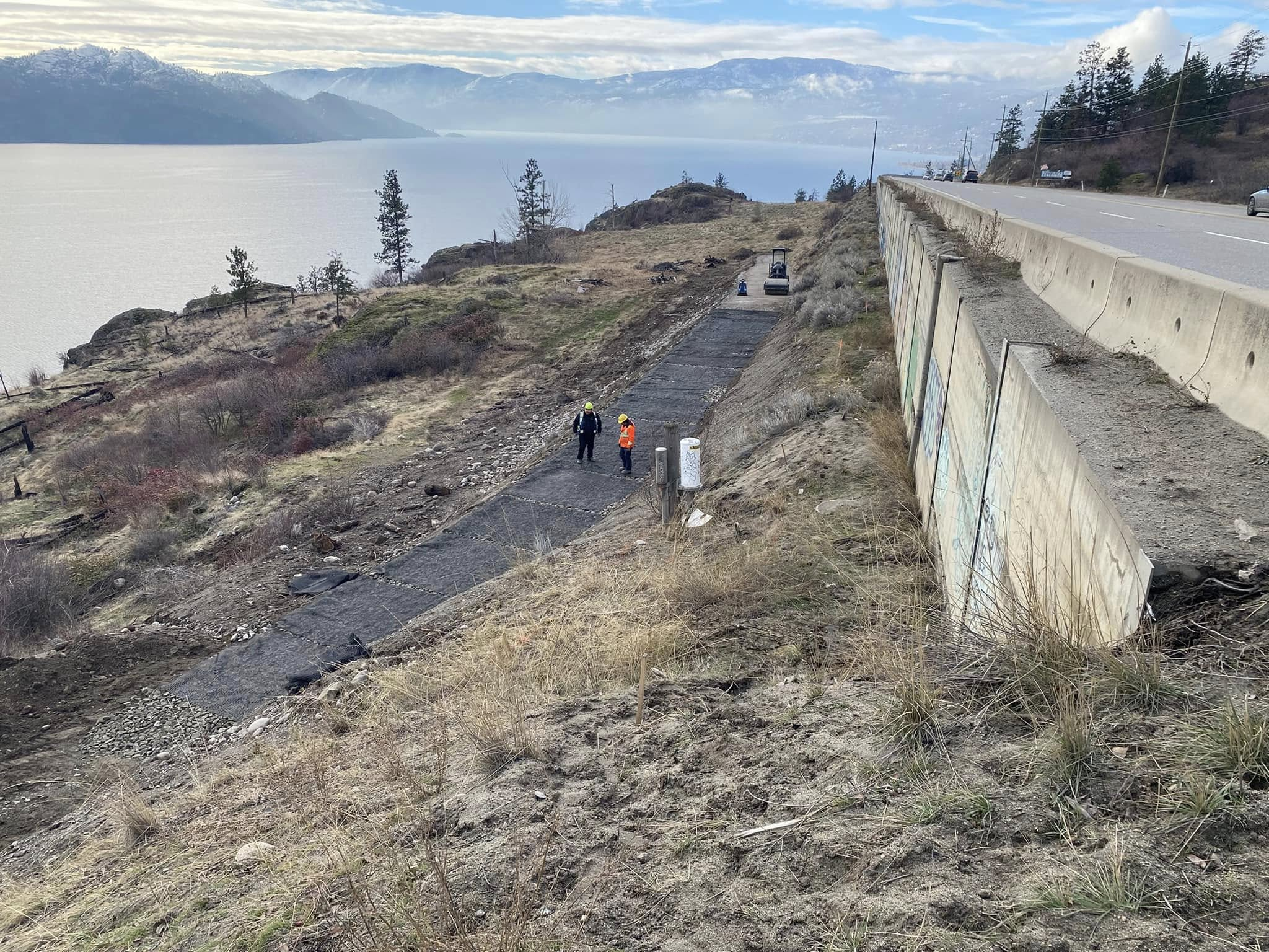
The Penticton Indian Band (PIB) in B.C.’s southern Interior has closed a 32-kilometre section of a popular hiking and biking trail on band-owned land because of large sinkholes, rockfall and instability along the route.
The trail, known as the Kettle Valley Railway (KVR) corridor, is closed from Summerland in the north to Kaleden in the south. The trail offers hikers and cyclists scenic views of Okanagan Lake, Penticton and Skaha Lake.
The affected section of trail sits on a piece of land that was returned to PIB ownership in 2022. Since then, the public has continued to use the trail, which connects to other sections of the KVR.
But the band said recent storms have damaged the corridor, which was already eroding, and that “several portions of the trail are now severely compromised, impassable, and unsafe for any form of public use."
“The risks are far too great for anyone to be on this trail,” said Greg Gabriel, chief of the PIB.
“We are asking everyone to respect this closure so that no one is put in harm’s way. Our community and visitors must be protected, and we cannot allow anyone to access an area that is this unsafe.”
A sinkhole is shown along a section of the KVR corridor trail on land owned by the Penticton Indian Band, near Penticton, B.C. (Penticton Indian Band)
James Pepper, director of natural resources for the band, said there are a few sinkholes “10 to 15 feet deep” on the northern part of the affected section.
An assessment has revealed that wooden pieces of the old railway structure are part of the problem.
“We've done a geotechnical assessment and what we've determined in that area is that there are some really old trestles underneath the trail bed,” Pepper said on CBC’s Daybreak South.
“So at some point in time, they were buried rather than removed, and now they're starting to rot, and so the top of the trail has nothing to sit on as they rot.”
A section of the KVR corridor is closed to trail users because weather and erosion have made it unsafe
The Penticton Indian Band is enforcing the closure of a section of the KVR corridor because recent weather events have made it unsafe. James Pepper is the director of natural resources with the Penticton Indian Band.
Pepper said it’s unclear how far the trestles extend, and where exactly all of them are located.
“And so at any given time, someone could just simply fall through, or a bike rider could fall through, or something like that,” he said.
On the southern part of the impacted section of trail, near Banbury Green in Kaleden, the problem is a large boulder that fell from a cliff face.
“People who walk the trail or ride it know that there’s a long section of pretty vertical cliffs, and so on [Nov. 17] we had a car-sized boulder fall off the side of one of those cliffs and almost completely block the trail,” Pepper said.
“And the rest of it is pretty unstable, so that section is incredibly unsafe. It needs proper rock scaling, so we’ve closed the trail because of these two significant issues.”
Due to safety hazards, people are being asked to stay off a 32-kilometre section of the KVR Corridor trail on land owned by the Penticton Indian Band. (Penticton Indian Band Guardian Program)
The PIB said it has repeatedly posted “no trespass” signs along the trail, but that public use has continued, and signs have even been torn down.
In response, Pepper said the band is placing its own people along the corridor to keep watch.
Future of trail section up in the air
For multiple reasons, Pepper said it’s unclear if or when the trail will reopen.
“We need to have a restoration plan,” he said. “You can appreciate how challenging it's going to be to get these trestles out of the ground and to remove car-sized boulders. And then we need a long-term maintenance plan.”
While the PIB has been maintaining the trail, Pepper said the band also works with the Regional District of Okanagan-Similkameen, Trans Canada Trail and other trail organizations on upkeep.
He said a collective effort will be needed to be able to move forward with repairs, and he expects the capital cost of any fixes to be significant.
Ultimately, Pepper said band membership will make the decision on the trail’s future.
“There are many benefits to PIB to keeping the trail open,” he said. “So, not speaking for them, but it’s a beautiful trail. We just need to fix it up.”
Tourism Penticton said it doesn’t have statistics for how many people use the KVR corridor trail on an annual basis. The organization did say the trail is very popular but declined further comment.

Janice Liebe, president of the Trail of the Okanagans, and Bruce Dalrymple, president of the Gellatly Bay Trails and Parks Society, pose at the Talking Circle at the Peachland to West Kelowna Multi Use Path ribbon cutting celebration. The 2.7 kilometre path links Peachland and West Kelowna without using Highway 97. Photo: Barb Aguiar
Barb Aguiar - June 29, 2025
Some 25 years after the idea was conceived, cyclists and pedestrians can now travel between West Kelowna and Peachland without risking injury on Highway 97, thanks to the Peachland to West Kelowna Multi-Use Trail, which celebrated its grand opening.
The 2.7-kilometre-long path links West Kelowna from Seclusion Bay to Peachland and offers users not only safe passage, but also sweeping views up and down Okanagan Lake.
The connecting trail has been a long time coming.
The Gellatly Bay Trails and Parks Society was asked to bring a trail to Peachland 25 years ago, said Bruce Dalrymple, the society’s president and a retired engineer with a love of the outdoors.
“We couldn’t, because Goat’s Peak was not a park. It was private property,” said Dalrymple.
When Goat’s Peak opened in 2015, the society began working with Peachland and the Ministry of Transportation and Infrastructure to put the trail through.
It was a challenge to find a design that the Ministry of Transportation would accept; however, what was once a deer trail is now a 10-foot-wide path built with 6,000 tonnes of crushed gravel.
Peachland Mayor Patrick Van Minsel said the $2 million project was funded by over $920,000 from the B.C. Active Transportation Grants Program, $356,000 from the federal Communities’ Active Transportation Fund, and $400,000 from the District of Peachland. The Ministry of Transportation and Infrastructure donated fill as well as highway barriers. “Now we’ve got to encourage people to use it,” said Garry Wittich of the Gellatly Bay Trails and Parks Society. “Once they come out and see what a beautiful job the contractor has done, I think they’ll use it a lot.”
Craig Thompson was part of a group of cyclists that pedaled from Heritage Park in Peachland for the official opening. “It took us about 20 minutes,” he said. “Depending on the type of bicycle you’re riding, you have to work at it.” It was Thompson’s first time cycling the trail, but he can see himself riding it frequently. “I think it’s fantastic for the community and for being able to connect West Kelowna to Peachland,” he said. “I think we need to move to a more active transport solution,” said Lloyd Stinson Sotas of the Peachland Outdoors Club. “A lot of people do commute back and forth. I think, from the business perspective too, restaurants will have a grand time on both sides, with new customers coming for a beer after they’ve had an invigorating cycle.”
The trail also represents part of the valley’s rich history.
The opening of the Peachland to West Kelowna section brings the Trail of the Okanagans Society closer to its dream of a 370-kilometre-long hiking and cycling trail from Sicamous to Brewster, Washington.
“This stretch—2.7 kilometres—may be short, but it’s very important because it’s the most technically difficult piece of the trail to build,” said Janice Liebe, president of the Trail of the Okanagans Society, an advocacy group focused on trail sections between the Bennett Bridge and the Canada–U.S. border. “It’s essential to have this piece so we can continue to build south and north, and connect all the way from Sicamous in the north to Brewster, Washington.”
The original Trail of the Okanagans, carbon-dated to be more than 6,000 years old, was a major trading route that connected the Syilx Okanagan communities.
The society is following the original trail as closely as possible as it works to stitch together more than 100 individual pieces of a fragmented linear hiking and biking pathway that exists from Osoyoos to Kelowna.
“We’re hoping today really inspires a lot of other communities to say, ‘Hey, I want to be a part of that,’” said Liebe. “The City of West Kelowna is actively working on our portion of the Trail of the Okanagans by embedding it within our Transportation Master Plan, currently in progress,” said West Kelowna Mayor Gord Milsom.
The ribbon-cutting ceremony took place at the Talking Circle, a feature designed to bring people together—where they can stop, take in the breathtaking view, picnic, drink some water, and ponder the long history of the valley.

Pathway to open soon
Kathy Michaels - Apr 3, 2025 / 2:42 pm | Story: 542365
Photo: The Trail of the Okanagans Society
The multi-use pathway linking Peachland to West Kelowna is expected to open in May.
The multi-use pathway linking Peachland and West Kelowna is expected to be open in May.
Funding for both phases of the trail was announced late last month. A District of Peachland representative said it will start just north of the intersection of Highway 97 and Buchanan Road and end near the Seclusion Bay underpass in West Kelowna.
It’s 2.8 km long and will connect with Goat’s Peak via an on-road portion, Seclusion Bay Road.
The project is supported by the Trail of the Okanagans which is hoping to connect three trail systems from Sicamous to north of Osoyoos.
"This is considered a key connection for this project and a fully-connected trail system is expected to vault it to international significance from a tourism perspective," district staff said.
The district said in an online post that it successfully applied for a grant of up to $500,000 and received a federal contribution of up to $356,400 for the project through the Government of Canada's Active Transportation Fund.

January 6th Update: The warm weather means that construction has been able to continue on the Peachland trail connection. Flury Construction is adding fill on an old access road to reduce the grade from 18% to 9% to make the slope easier to navigate. They are now bringing in gravel from the big slide on Highway 97 south of Peachland. It is estimated that this section will take about two weeks to complete. After that, they will push south across an old orchard site. Then, the most challenging section is connecting to the top of Drought Rd. This will be the most technical part, with a 20 m depth of fill required across the steep side slope. That piece will take at least two months to construct.

And so it begins! Day one of construction of the multi-use pathway between Goats Peak Park in West Kelowna and Peachland
Check back often to see the progress!
Final approvals given to new trail linking Peachland, West Kelowna
Work to start on new trail
Pat Bulmer - Oct 25, 2024 / 9:00 am | Story: 513725
Construction of a trail between Peachland and West Kelowna can begin.
Peachland council on Tuesday approved a budget amendment that allows money to be spent on the trail construction.
Council received $776,000 in grants from the provincial and federal governments in August to build the 2.6-kilometre multi-use trail. The municipality is putting in $400,000. That money comes out of a provincial infrastructure grant awarded to the municipality last year. Council will apply for a grant for phase 2 of the project, Mayor Patrick Van Minsel said in a statement to open Tuesday’s regular council meeting. The trail to Goat’s Peak Regional Park is designed to be part of a 250-kilometre pan-Okanagan trail that proponents hope will be completed some day.

Photo: Colin Dacre
A path in Goat's Peak Regional Park.
Kelowna News
Okanagan cycling advocate calls on province to design, fund bike trail networks

A specially designed staircase with a rail for bicycles is a vital cycling link between West Kelowna and Peachland and, ultimately, from Sicmous to Osoyoos and beyond. While cheering the fact that construction has started on the staircase, the president of the Trail of the Okanagans Society says the province has to get way more involved in designing and funding what’s known as active transportation. “If the goal, in the long term, is to have active transportation have a much greater modal share, then the infrastructure has to be there,” Janice Liebe told iNFonews.ca. “When the government designs transportation, they design them as networks and that’s not the approach they are taking to active transportation. We want to add to that conversation saying, if you want active transportation to be successful, you have to consider it as a network. You have to design and fund it that way too.”
The Trail of the Okanagans Society is working to complete the southern part of what is hoped to be a mostly rail trail from Sicamous to Osoyoos. Its focus right now is two-fold – connecting communities from the south heading north and cementing a safe cycling route between the Bennett bridge in West Kelowna to Peachland. Last month, the Regional District of Central Okanagan announced it bought land north of the Goats Peak Regional Park. That’s now part of the park and work is underway to connect the exiting park pathway down to the Gellatly Nut Farm.
That includes a stairway up the steep slope on the north side of Goats Peak with a rail on one side to make it easier for cyclists to push their bikes up and down. Construction has started and is expected to be finished this summer.
READ MORE: Major connection along Trail of the Okanagans to open this summer
There is still work to be done through West Kelowna where the trail is expected to mostly follow Boucherie Road. The bike path on parts of that road is, at times, only on one side of the road and does not meet provincial guidelines for width safety. On the south side, Goats Peak’s Sagebrush Trail ends at the intersection of Seclusion Bay Road and Highway 97. The society has applied for more than $500,000 in government grants to build a trail down the side of Drought Hill to Buchanan Road. The total estimated cost is just under $600,000 so more grant applications are in the works.
READ MORE: A trail from Sicamous to Osoyoos depends on West Kelowna to Peachland problem
“This is the section we said is the most expensive per linear metre between West Kelowna and the American border,” Liebe said.
If the funding comes through, she hopes construction can start next spring for completion before the end of the summer. The grant process is part of the problem with the way bike paths are funded, Liebe pointed out. Numerous groups and municipalities in B.C., and across the county, are competing for the same money from the federal and provincial funding programs. That’s where treating bike paths as part of a transportation network comes in, especially when it comes to highway crossings. Too often they’re being designed without cyclists in mind so municipalities are faced with the costs themselves or competing with non-profit groups for scarce funding. An example of that is in Kelowna. The city received a $2.4 million federal infrastructure grant to connect the Houghton Road cycling route in Rutland to the Okanagan Rail Trail, across Highway 97, even though that part of the highway was redesigned and expanded fairly recently. Work on that project is expected to start in June and be completed in October.
That’s an example of the “catch-up” that cycling advocates are faced with because such crossings are not included in highways projects.
“Currently, even though the Ministry of Transportation and Infrastructure are responsible for active transportation, they’re going through an evolution of incorporating the principles that they actually authored through the B.C. Active Transportation Design Guidelines,” Liebe said. “They currently do not include those as part of intersection upgrades so it’s up to communities to advocate for that and/or having to pay for and play catchup after those intersections are designed.” It is even more challenging in rural areas of the province, she said. “If you’re designing an active transportation program for the province, it’s one thing to say, hey, let's connect a bunch of communities in urban Vancouver or Victoria,” Liebe said. “But, in rural communities, we’re really talking about active transportation between communities and it becomes more complex because you’re now moving outside the municipal boundaries. Often, you’re crossing either Crown land or First Nations reserves or regional parks so the conversations become much more complex.”
The focus of the group is to connect communities with safe routes that provide a destination, rather than having bits and pieces built that may, some day, connect with others. “We’d like to be able to see programs that focus on connecting communities that are less than 25 kilometres apart, because that’s a good range to cycle, there and back, and enough for people to commute between communities,” Liebe said. “A good example of that is, when the Okanagan Rail Trail opened and they met their five year projections in the first six months, that really showed what the latent demand is for cycling,” she continued. “The reason that was so successful, even though that trail is not fully connected yet, is that it had lengths of trail that were meaningful to ride on and got you from place to place. We feel, as a strategy, if we build longer sections of trail that get people out riding, it will demonstrate the desire and build the voice for the trail in the South Okanagan.”
VIDEO: Trail of the Okanagans bike path from Sicamous to Washington making progress
Okanagan posted Apr 29, 2022 @ 06:40pm by Sarah Jones

It’s been in the works for a number of years, a hiking and cycling trail that spans the length of the Okanagan Valley and across the US border. The vision is straightforward, a single 370 km trail starting up in Sicamous, BC and travelling down the valley into Brewster, Washington. Trail of the Okanagans plans to trace traditional trading routes of the Okanagan First Nations that will skirt along lake edges, wander through forests and hillsides, borders vineyards and fruit orchards. With over 100 existing paths already in the area, the goal is to connect and merge them into one large spine.
At this time members are specifically focused on bridging the 125 km section between Bennett Bridge in Kelowna down to Osoyoos.
“About 75% of the section between West Kelowna and Osoyoos is currently connected, and about 25% of that is to what we call an ‘all ages and abilities standard’. We’d like to see all 125 km to that standard,” explains Janice Liebe, President of the Trail of the Okanagans. “There are a number of gaps. Pieces in the Vaseux Lake area, pieces around Penticton, but our strategy is to sort of work from the south; from Osoyoos up to Gallagher Lake and from West Kelowna connecting to Peachland.” Recently the Trail of the Okanagans has made major progress with help from the Gellatly Bay Trails and Parks Society. Read full article here:
Two regional parks in West Kelowna grow through land purchases. Regional parks growing
Victoria Femia - Mar 1, 2022 / 12:47 pm |

The Regional District of Central Okanagan is announcing the purchase of two properties that will expand regional parks and connect them to nearby neighbourhoods. A new 10.6 hectare property at the end of Whitworth Road has been purchased for $2.2 million and will be added to Goats Peak Regional Park. The area that is expected to open late this summer, will provide legal access from Whitworth Road and a connection for Gellatly Nut Farm Regional Park. The RDCO says this acquisition will ensure critical ecosystems, habitat, species at risk and important First Nations values are protected while providing opportunities for planned trail connections.
Full article: https://www.castanet.net/news/West-Kelowna/361462/2-regional-parks-in-West-Kelowna-grow-through-land-purchases?fbclid=IwAR33HVUSEnWKtg1zZkoPHuQJzjg-cG4bQAslaWqbDdjqOSx-Y9P4ZLvxqVs#361462

A 26-acre land purchase by the regional district will formally connect Goats Peak Regional Park with Whitworth Road in West Kelowna. The land purchase was announced by the Regional District of the Central Okanagan today, March 1. “It’s going to be an amazing portion of our regional parks system,” Wayne Darlington, the regional district’s parks planning manager, told iNFOnews.ca. “The expansion of Goats Peak is a pretty amazing piece of land that protects cultural and ecological interests in our area, so it’s awesome.” The 128-acre Goats Peak park was opened in September 2019, but the trail down into West Kelowna was fenced off since it ran through private property.
READ MORE: New Goats Peak regional park doesn't quite connect to West Kelowna
This shows the new parkland in the yellow hatched section. the red line is the existing trail network in Goats Peak Regional Park.
Image Credit: Submitted/Regional District of Central Okanagan
With the help of the federal government, the regional district bought the land for $2.2 million and will spend the next few months to get it ready for public use, hopefully by early summer. While the trail itself is in fairly good shape, the connection to Whitworth Road is rough and requires some scrambling over loose rocks up a cliff, Darlington said. The plan is to build about 15 stairs up the cliff with a “bike rail” attached. “You put your bike in the rail and it holds your tire on the rail so it’s easier to push it up and you don’t have to go over the steps,” Darlington explained. “It rides smoothly up the stairs so you hop on your bike and away you go. It may be challenging for electric, but they might be able to give a little throttle bump as well.”
There’s a road through the park the leads to Seclusion Bay Road on the Peachland side. It will still be a challenge to get down into Peachland but the Trails of the Okanagans Society is working with Peachland on a potential switchback trail on Drought Hill beside Highway 97.
Read full article here: https://infotel.ca/newsitem/major-connection-along-trail-of-the-okanagans-to-open-this-summer/it89238?fbclid=IwAR3L9QoPYc9vC5AgJTujZtNYz7HjRGo2F-ey4beN_TaRw3M1TGtCaZICABI
Vaseux Lake group opposed to west side bike trail
Lyonel Doherty Times Colonist News November 17, 2021

File photo
A proposed hiking and biking trail on the east side of Vaseux Lake is prompting environmental concerns by the Vaseux Lake Stewardship Association.
Chair Norm Gaumont noted the trail in question on the old KVR rail bed poses a significant risk to endangered birds and wildlife. He also said it flies in the face of a previous government report that recommends an alternate route on the east side of the lake. Gaumont pointed to a 2018 environmental feasibility study prepared for the B.C. government outlining the impacts that such a trail would have on endangered species and sensitive habitats.
He noted the study consulted with biologists and other key stakeholders before recommending a bike route along Highway 97 on the east side of the lake, away from sensitive areas such as nesting sites. But Gaumont said the regional district is putting forward a proposal to establish the path on the west side. He stated this new proposal failed to consult with key stakeholders even though a “decision was made to move the bike path through a sensitive bird and wildlife refuge.” Gaumont said the trail will attract a large number of people, especially during spring and summer months when stress on wildlife increases. “While the proposal says hikers and cyclists must remain on the railway bed and not venture into federally protected areas adjacent to the bike trails, it will be impossible to totally stop people from going off trails.” Regional director Ron Obirek (Electoral Area D) said there is a long history behind this massive trail system. He noted that 25 years ago the province re-acquired the right to the trail on the west side of the lake for the benefit of hikers and cyclists. Obirek said the long-term visionary goal is to get all of these trails connected for the benefit of everyone, including tourism. But the director did acknowledge the environmental uniqueness of Vaseux Lake, pointing out issues such as siltation, milfoil and water quality.
He also noted the sensitive bird sanctuary and the challenge to get man and nature to co-exist in this area. Obirek suggested building an elevated trail structure to minimize the impact on the surrounding environment. Signage is another idea he suggested. The fact is most people don’t come here with the intent of harming the environment, he said. When asked about putting the trail on the east side of the lake, Obirek didn’t jump on that bandwagon.
“The idea of going on the east side is problematic, it’s a narrow road and dangerous . . . adding bikes and pedestrian traffic is not a good option.”
Area C director Rick Knodel said he favours the alternate route on the east side along some of the vineyards. He noted the potential conflict on the west side with the Thomas ranch land. The other concern is the disruption of snake habitat, he pointed out. East or west, both regional directors don’t see the trail being established anytime soon. Obirek said he supports the process of gathering the necessary input from the public and area stakeholders.
Janice Liebe, president of the trail advocacy group called Trail of the Okanagans, said biologists who have studied the area in question found that it is entirely possible for trails to co-mingle with wildlife habitat through proper design. “We agree that a careful design approach is required and we would expect that this would be vetted by many prior to actual approval of the trail to advance. We care about the habitat, too,” Liebe said. She noted that a study found the railbed to be in excellent condition with exposed gravels, and that the habitat is functioning with the trail there. Liebe said what is often left out of the conversation is that there is no room for a safe, fully-protected from traffic trail on the east side. “What would the environmental impact be of building into Vaseux Lake for a trail or carving out the cliffs?”

From Peachland to Goat’s Peak: Trails Society is getting closer to making that pathway happen
Peachland Phoenix
Written by Kristen Friesen October 26, 2021
It’s going to be tricky – a trestle may even be part of the planned construction. But by spring, the Trail of the Okanagans Society hopes to make a huge step forward in creating a bike / hike-friendly trail from Peachland all the way to Goat’s Peak Regional Park, up by Seclusion Bay.
President Janice Liebe says the group hired a geotechnical engineer so they’d be in a better position to get the project approved by the Ministry of Transportation (as much of the planned pathway is within the Hwy 97 / Drought Hill easement).
“We want to be in that position so we can be looking at what we can fundraise to make this connection work,” she says, explaining that so far, the response from MOTI on the engineering details has been positive.
“We’re going to complete those engineering details and if we have final approval from MOTI when that’s done, we should have a shovel-ready project ready to start fundraising and find grant funding for in the spring, which is very exciting.”
There’s more than 100 different sections of trail between Bennet Bridge and the Canada / US border – the vision of the Trail society is to create a single, 370-km long hiking / cycling trail that extends from Sicamous all the way to Brewster, Washington. The route roughly makes its way along a large section of Okanagan Lake, and Liebe says one of the Peachland sections, from Buchanan Rd to Seclusion Bay Rd, is among the most challenging.
“Essentially it stays entirely within the Ministry of Transportation easement, so below the highway,” she says.
The plan is for a short, protected section of pathway to be on the highway, just off the Buchanan intersection. Then, where that first pullout is located before you go up Drought, the pathway will go down onto the original part of Drought Rd, which is currently blocked off. Further up the hill, closer to Seclusion Bay and the entrance to Goat’s Peak park, is where some serious engineering will take place:
“There’s a significant piece of (construction) we have to do there, with retaining walls and a trestle to get us over to Seclusion Bay,” she says, adding thankfully, there’s also a flat piece of land the pathway can easily traverse across.
“And this is why we’ve hired a geotechnical engineer who will do the design work that needs to be approved by the Ministry of Transportation to their standards,” says Liebe.
“This is not a matter of plowing the land and putting some gravel down.”
Engineering fees for this leg of the project is $14,000. The Trail of the Okanagans Society managed to raise $10,000 through a grant and private donations. On tonight’s council agenda, there’s a request from the Peachland Tourism and Economic Development Committee. A total of $4,500 was already earmarked for them in the municipal budget, and the request is to use $4,000 towards the engineering costs. (Update – that was approved unanimously during Tuesday night’s meeting.)
“We did a presentation to the Tourism and Economic Development Committee earlier this year to talk about the benefits to tourism in Peachland by connecting the trail, particularly the section between Peachland and West Kelowna,” says Liebe.
“Because as soon as that all opens up, in theory, you would be able to ride your bike from Peachland over to Kelowna and when the Okanagan Rail Trail is complete, with that section in Lake Country, you’d be able to get all the way to Coldstream. So essentially, this connects into the Okanagan Rail Trail.”
Today, the Trail of the Okanagans Society is meeting with District representatives and a consultant, to walk another section of trail that will go through Peachland. That’s thanks to another grant the society received – $10,000 to study how the Trail will go through town, between Hardy Falls (right at the beginning of the Fur Brigade Trail), and Buchanan Rd.
“Right now it’s not design work, it’s planning work,” Liebe says.
As the entire project sits now, about 70% of the entire trail is cycle-able. There’s some big sections that still need to be brought into the network, notably in the south Okanagan.
“Those are big sections of trail that require a lot of work and there are issues of access, the environment, so it’s complicated. But we’re working, frankly, everywhere we can.”
That includes liaising with local cities, towns, regional districts and First Nations leaders. The Trail of the Okanagans Society recently received a $15,000 grant to start some consultations – a listening exercise, Liebe says.
“We want to deliver the trail in partnership with Westbank First Nations, Penticton Indian Band and the Osoyoos Indian Band. We’re just starting that work now – what they would like to see, how they would like to participate, what’s important to them. So really, it’s a listening exercise for us to go through that.”
In all, she sees the Trail of the Okanagans Society as the glue that’s allowing these sections to be built.
“We don’t physically build the trails, but we’re working to create the vision of connecting all of these various areas and we do write grants to assist municipalities to help fund the work that needs to be done. For example, we found the funding for the engineering between Buchanan and Seclusion Bay. That’s not going to be a cheap piece of trail, so there will be a fundraising piece that comes out of that. But we see ourselves as the glue, bringing these various partners together to talk about this and to see what can be done. And we’re gaining momentum.”
Want to learn more about the Trail of the Okanagans Society? Here’s their website and their Facebook.
***
And if you enjoyed this article – and want to know more about this local, independent journalism business I started (just me and my laptop!), see my About page. Thanks!
Penticton Now article posted Oct 2, 2021 @ 04:00am by Gord Goble
Sicamous to Washington State cycling/hiking trail (painstakingly) takes shape
Imagine there was an uninterrupted all-abilities biking/hiking/walking/running route spanning the entire length of the Okanagan..
You could reach this imaginary route with just a short walk or ride from virtually any spot in the valley, then use it to journey as far north as Sicamous or as far south as the border. And potentially in the future, all the way through the border to Brewster, Washington (the approximate southern boundary of the ancient First Nations "Okanagan" region).
Read the full article:
https://www.pentictonnow.com/watercooler/news/news/Penticton/Sicamous_to_Washington_St…
Photo credit: Now media
Kelowna News September 14, 2021 - 8:45 AM by Rob Munro
Rail Trail along Vaseux Lake a distinct possibility

After years of discussion and reluctance of senior government to allow the old Kettle Valley Rail Line on the west side of Vaseux Lake to be opened to the public, there is now a light at the end of that tunnel.
Janice Liebe, President of the Trail of the Okanagans Society, now has an agreement with provincial and regional governments to draft a parks plan for the 6.5 km stretch of the rail line.
“This is a very exciting development and one that has been a long time in the making,” she said in a news release. “It has taken considerable effort on the part of government and volunteer groups over the last decade to get to this point.”
A section of the KVR Trail along Vaseux Lake
Read more here: https://infotel.ca/newsitem/rail-trail-along-vaseux-lake-a-distinct-possibility/it85772
Image Credit: Wikimedia commons
Peachland View October 4, 2021
$10,000 Grant for Peachland Trail Segments

Good news!! Through the District of Peachland, The Trail of the Okanagans applied for and received $10,000 for trail planning for the connection between Peachland and Goats Peak Park. We are also working with the Ministry of Transportation and Infrastructure supplying engineering details for their review and approval to construct the Trail over this complex section.
Okanagan Rail Trail
Castnet News, March 30, 2021 Darren Handschuh
Friends of Okanagan Rail Trail produce brochure and map of popular attraction Rail trail map guide

More Okanagan Rail Trail News
https://globalnews.ca/news/7442427/donations-complete-three-sites-on-okanagan-rail-trail/
Shuswap North Okanagan Rail Trail
Summerland Review July 30,2021
Grant funding grows for pilot section of Shuswap North Okanagan Rail Trail

More than $700,000 in grant funding is being put towards a pilot section of the Shuswap North Okanagan Rail Trail.
The rail trail team announced Thursday, July 29, that the ownership partners behind the project, the Splatsin, the Regional District of North Okanagan and the Columbia Shuswap Regional District, were awarded a $459,061 in COVID-19 Resilience Infrastructure Stream funding from the governments of B.C. and Canada.
The funding will be combined with a $250,000 grant received from the B.C. Ministry of Tourism in March 2021, and used to fund the construction of a pilot section of rail trail within City of Enderby and Splatsin territory.
To read more click here: https://www.summerlandreview.com/news/grant-funding-grows-for-pilot-section-of-shuswap-north-okanagan-rail-trail/?fbclid=IwAR3nzJe3C7gMjw96kafgHNb_7_-lI5RiHgVfH6BC--ci5sbmzPVKOX46C4M
More news about the Shuwap North Okanagan Rail Trail
https://globalnews.ca/news/7726459/second-stretch-rail-trail-corridor-okanagan/
https://www.google.ca/.../second-stretch-rail-trail.../amp/